
Dangerous Storms Expected Today with Tornadoes, Hail, and High Winds Possible
Widespread severe storms expected—residents urged to have multiple ways to receive alerts

Orange Beach, Ala. – (OBA) – The National Weather Service in Mobile is warning residents of a significant severe weather event expected to impact the area today and tonight. Forecasters say conditions are favorable for a severe thunderstorm and tornado outbreak, with the potential for long-track, violent tornadoes, damaging wind gusts exceeding 70 mph, and large hail up to two inches in diameter. While the morning may be relatively quiet, storms are expected to develop rapidly during the afternoon and evening hours, moving eastward across the region.
A High Risk (Level 5 of 5) for severe weather has been issued for the northwestern parts of the area, with a Moderate Risk (Level 4 of 5) elsewhere. Officials stress that all areas should remain prepared, regardless of specific risk levels. Residents are urged to have multiple ways to receive weather alerts and to take warnings seriously. Storm activity is expected to diminish overnight into early Sunday morning.
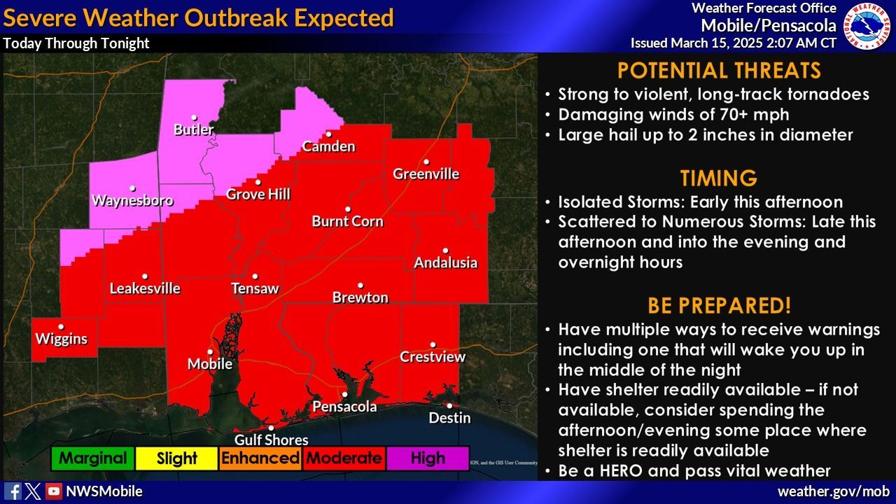
Overview from the National Weather Service-Mobile: A Severe Thunderstorm and Tornado outbreak is likely today into tonight across much of the region. There will be a relatively calm period this morning, but don't let this fool you as scattered to possibly numerous thunderstorms are expected to develop and move east across the area during the afternoon and evening hours. The environment will be very supportive of a likely severe outbreak. Long track, significant to violent tornadoes, large hail to 2 inches in diameter, and damaging wind gusts over 70 mph will be possible in any storms that develop.
Severe Storms:
Currently, our northwestern zones are outlooked in a High Risk [Level 5 of 5] for severe weather, while the remainder of the area is in a Moderate Risk [Level 4 of 5]. Please DO NOT focus on where the highest risk area is located. Our entire local area will be primed for significant severe weather, so do not let your guard down if you are located outside the highest risk area! Be sure to have multiple ways to receive warnings. Storms should diminish from west to east during the overnight hours Saturday into early Sunday morning.
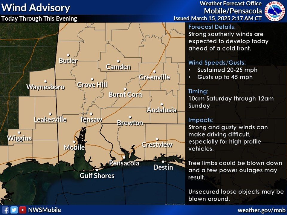
Non-thunderstorm winds: Outside of thunderstorms, it will be quite windy across the area. Over land, a Wind Advisory is in effect from 10am today Saturday through 12am Sunday across the entire local area. Sustained winds of around 20-25 mph, with gusts to around 45 mph can be expected.
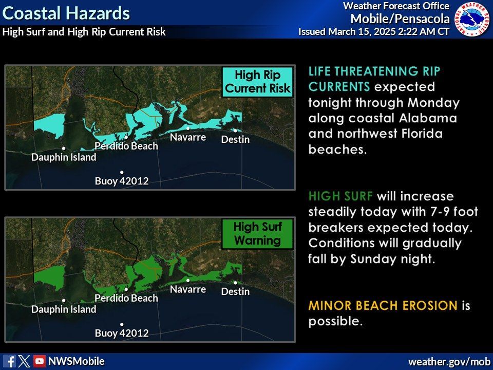
Beach/coastal hazards: The increase in southerly winds will bring dangerous surf conditions to our local area beaches. A High Risk of rip currents is in effect through Monday afternoon. A High Surf Warning is in effect from noon today through 6am Sunday for large breaking waves of around 7–9 feet. At this time, we are not expecting any large-scale minor coastal flooding, however, with the gusty winds and higher surf, some overwash may be possible for our prone barrier islands such as Ft. Pickens, Dauphin Island, and Santa Rosa Island. Some splash-over along the eastbound lanes of the Highway 90/98 Causeway across northern Mobile Bay could also be possible.
Share this article w/ Friends...