Est. 2006
OBA on Social Media
Blog Layout
Orange Beach officials: Sally's surge, rain could flood city homes
John Mullen • September 14, 2020
Tracking predictions for storm still trending eastward
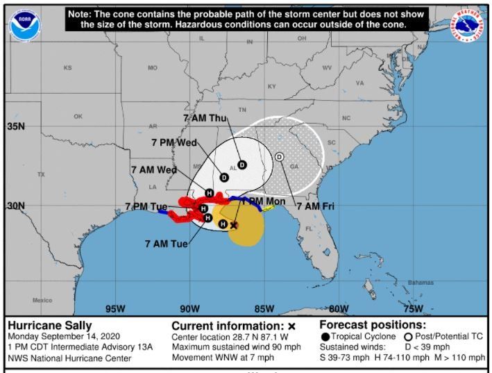
(OBA®) – Orange Beach officials are warning residents of low-lying areas that Hurricane Sally is likely to cause flooding including into homes in the city as it sweeps across the area. The city moved its meeting scheduled for Sept. 15 at 5 p.m. to noon on Sept. 14 and declared a state of emergency in the city.
“If we get six feet of storm surge which is what we are forecast for – we’re currently in the four- to six-foot range – if we get that six-foot storm surge on top of 20 inches of rain, we’re going to have structure flooding in Orange Beach,” EMA Director Lannie Smith said. “There’s no way around it. It just builds up and it has nowhere to go.”
Smith is also the city’s Building Official and wears the EMA hat during tropical events and storms. As the probable path continues to ease east toward the Alabama Gulf Coast those effects could intensify, Smith said.
“The track is heading east,” Smith said. “That can be a good thing and that could be a bad thing. We are now included in a hurricane warning. The wind speed probabilities have picked up for us however the closer we are to the center it gets us out of those outer rain bands so you are kind of making a tradeoff and we’ll have more wind. It depends on where landfall is. Right now, it’s basically showing landfall east of Gulfport.
“We’re still going to be on that northeast quadrant which is going to be some severe impact.”
The Sept. 14 update from the National Hurricane Center reported Sally’s top sustained winds were at 90 mph and all of coastal Alabama was under a hurricane warning as well as a flash flood warning.
Orange Beach is shutting down trash, recycling and vegetation and other pickups until Friday, Sept. 18. Gulf Shores City Schools and Baldwin County Schools announced on Sept. 14 it is closing schools on Sept. 15-16 due to flooding and other concerns because of the coming storm and its effects.
The city is also prepping crews to respond as the impact of the storm grows.
“We are prepared,” Smith said. “We’ve got two sandbag locations that are operating now and people are taking advantage of that. We’ve got one behind of city hall here and we’ve got one at public works. We’re ready with our hurricane signs for flooded streets, signs for water over the road and those type things.”
City Administrator Ken Grimes said this storm could bring more water than a rain event that dropped 26 inches of rain along the coast in 24 hours six years ago.
“One of the things is this is potentially greater than the April flood event of 2014,” Grimes said. “Looking ahead we’re going to close nonessential facilities for the next two days. This thing is going to wrap as it makes its turn. With all the rain we’re still going to have the rain potential and if it comes around, we’ll still be in it. That leaves the potential of high winds and heavy rains. Police, fire, sewer operations, those are essential.”
Police Chief Steve Brown and Fire Chief Mike Kimmerling both urged residents to stay at home when the worst of the storm approaches.
“Once we get to the storm itself everybody just needs to stay off the roads and stay home,” Grimes said. “The big reminder with rising tide, rising surf and rainfall of this magnitude is that though you may have a ditch, a pipe and a culvert when all this water has nowhere to go and this could actually last for several days. For public works they’ve been running tests to make sure things are working properly. We’ve prepositioned barricades and different roadblocks and things especially in the Bear Point area, Jubilee Point area where it’s already a foot over the bridge already.
“The key at the end of the day is to urge people to stay off the roads.”
Share this article w/ Friends...
Gulf Shores, Ala. – (OBA) – Gulf State Park invites families to the Spring Beach Campout. The cost is $45 per tent for up to four people, with additional guests at $5 each. A parking pass is included.
This family-friendly event is open to adults and children of all ages. Participants under 18 must have a responsible adult with them. Families should bring their own food, nonalcoholic beverages, and camping essentials. All drinks must be in non-glass containers.

Orange Beach, Ala. – (OBA) – The American Red Cross will hold a blood drive at Orange Beach City Hall to help meet the ongoing need for blood donations.
The drive will take place on Monday, March 31, from 8:30 a.m. to 2:30 p.m. at 4099 Orange Beach Blvd.
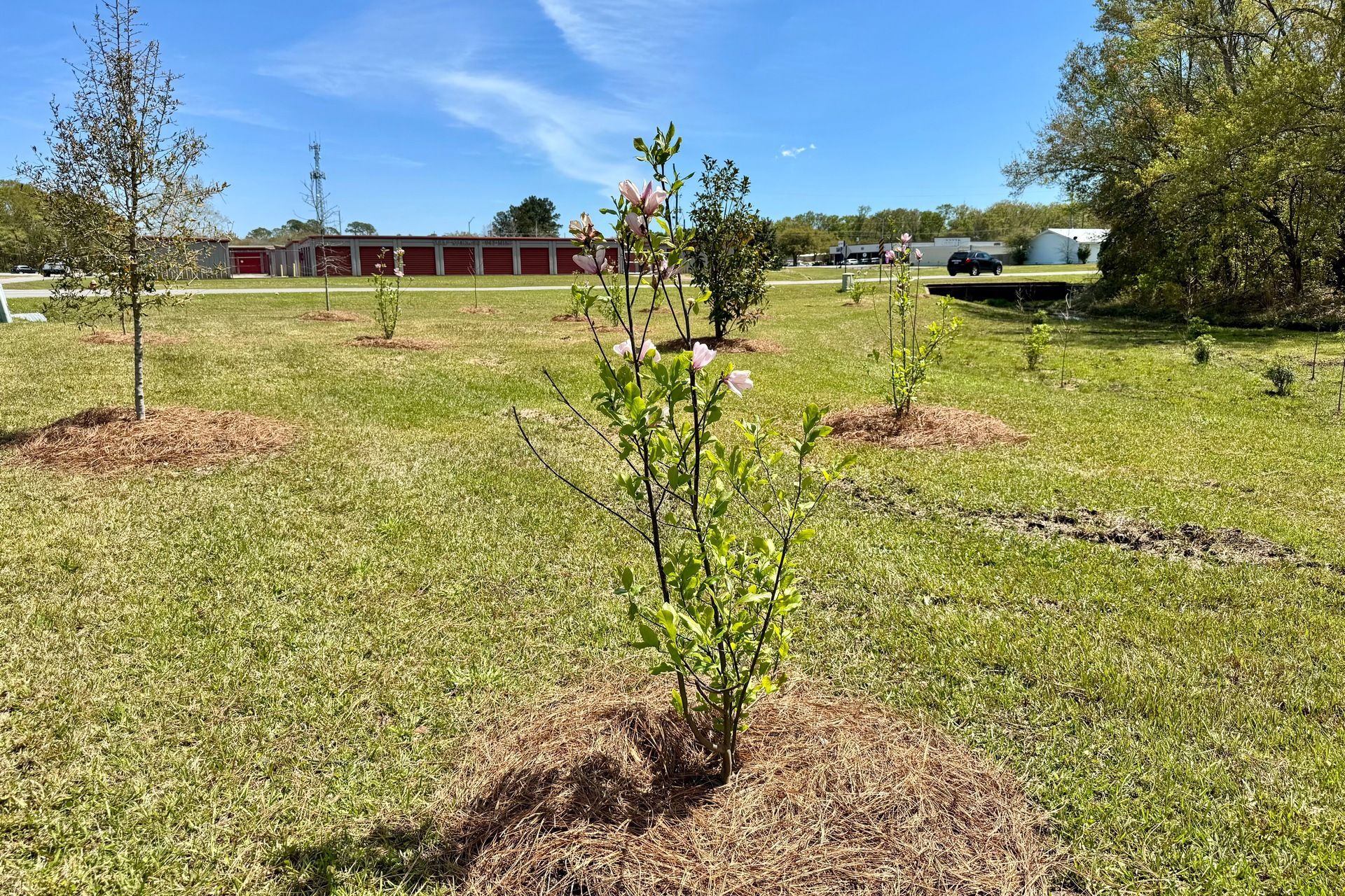
Foley, Ala. – (OBA) – Foley is making progress in bringing back the trees lost nearly five years ago when Hurricane Sally hit the area. City crews have started replanting trees to help restore the urban forest.

Elberta, Ala. – (OBA) – The Elberta German Sausage Festival kicks off today, March 29th at 8 am and runs until 5 pm. The Festival takes place at Elberta Town Park. This biannual event, held every March and October, celebrates Elberta's German heritage and supports the Elberta Volunteer Fire Department.
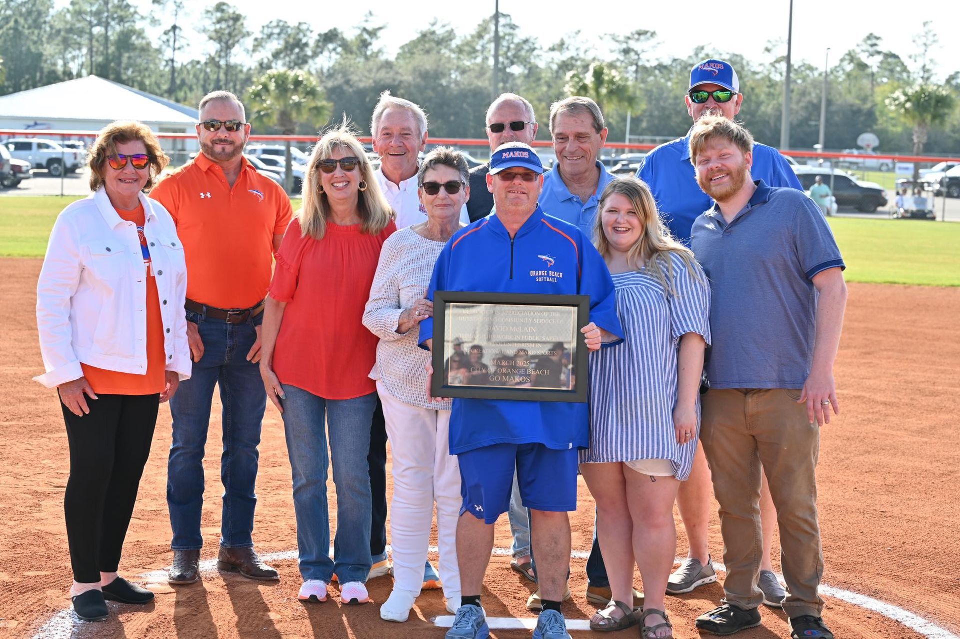
Orange Beach, Ala. – (OBA) – The City of Orange Beach kicked off its 2025 Baseball and Softball Season with a heartfelt tribute to longtime volunteer coach, David McLain. During the opening ceremony, Mayor Tony Kennon and the City Council surprised Coach McLain by dedicating Field 5 in his honor. Unaware of the plan, McLain read aloud the plaque's inscription at the center of Field 5, realizing the field now bears his name. He then threw the ceremonial first pitch, marking the official start of the season.
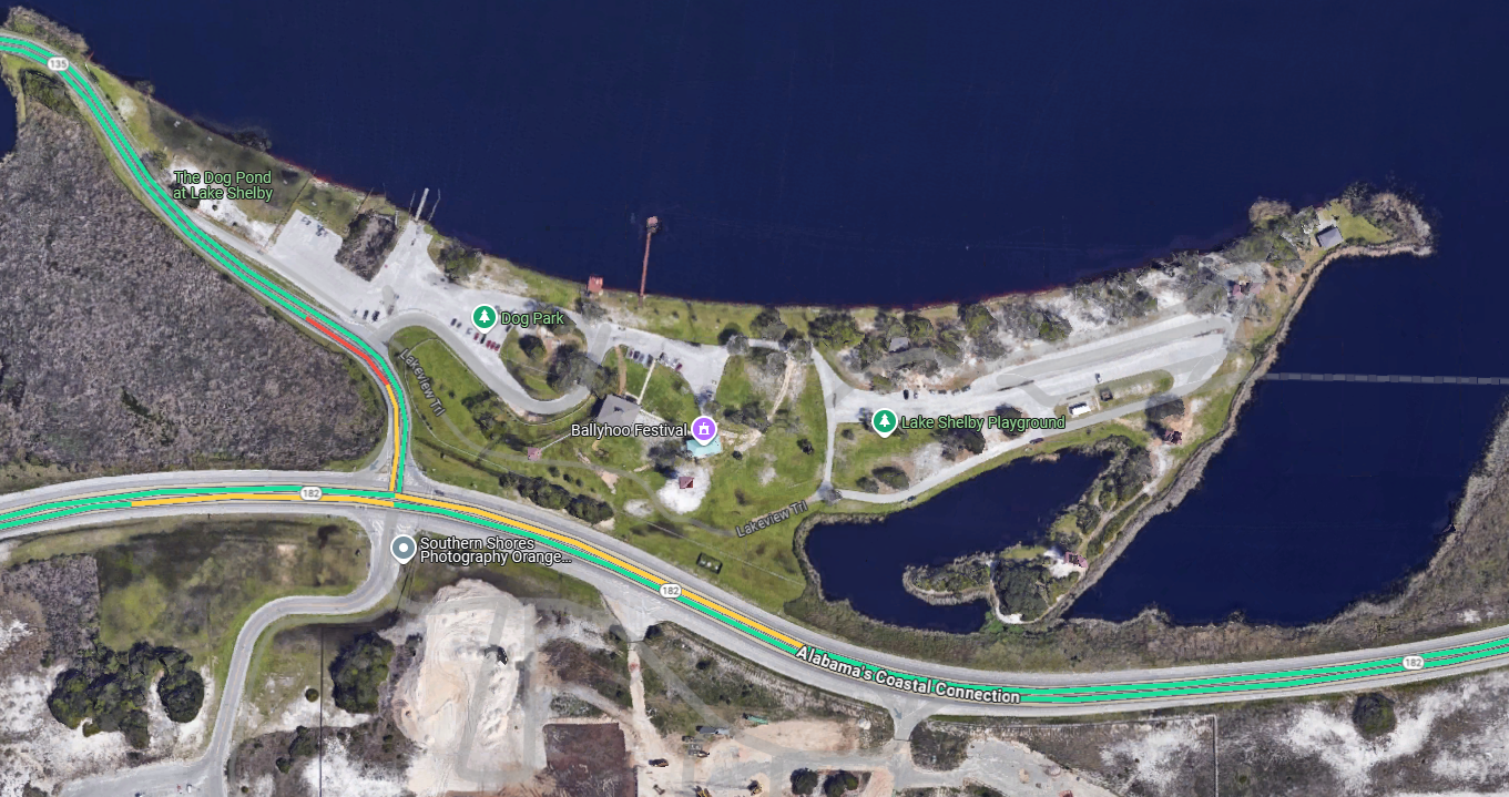
Gulf Shores, Ala. – (OBA) – The Gulf Shores & Orange Beach community will be celebrating this weekend at the inaugural L.O.L. Festival (Love Our Locals). The Festival kicks off today at the Gulf State Park’s Lake Shelby Picnic Area. This three-day event is dedicated to honoring local artists, musicians, food vendors, and businesses that make the coastal community thrive.
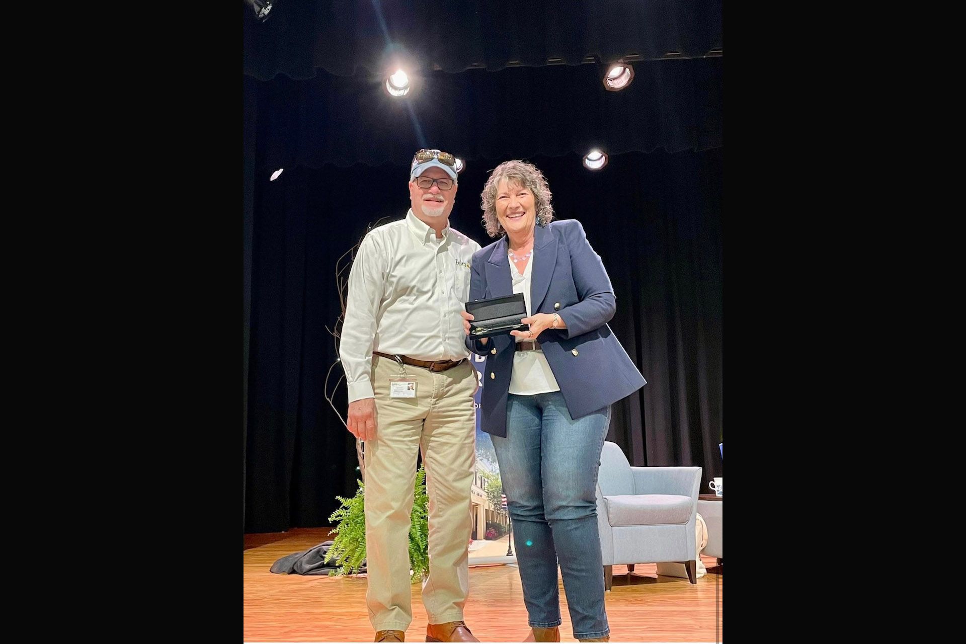
Foley, Ala. – (OBA) – The City of Foley recently honored celebrated Christian author Colleen Coble during a special presentation hosted by the Foley Public Library.
Coble, along with her co-author Rick Acker, participated in a series of events organized by the library. On Saturday, March 22, the Foley Civic Center hosted a book launch, author talk, and signing to celebrate the release of their latest novel, Ambush, which debuted on March 4.

Gulf Shores, Ala. – (OBA) – The Velcro Pygmies, known for their dynamic performances, will entertain and engage students in an interactive experience that promotes career exploration. This initiative offers insights into various industries, including music, production, and business, helping students discover their passions and potential career paths.

Orange Beach, Ala. – (OBA) – Mayors from Orange Beach and Gulf Shores have declared May 10, 2025, as C.A.K.E. Day. The event supports young entrepreneurs in starting and running their own businesses in the local community.
C.A.K.E. stands for "Creating And Keeping Enterprises." The program teaches students how to create and manage a business, including planning, marketing, and customer service skills.

Foley, Ala. – (OBA) – The Gulf Coast Hot Air Balloon Festival will return to Foley in the first weekend of May, bringing three days of live music, family activities, and hot air balloon displays to the area. Presented by Columbia Southern University, the annual event remains free to the public and continues to draw thousands of visitors from across the region.