
Severe Weather and Shelter Updates for South Baldwin County
Below are updates from our local authorities...
Orange Beach, Ala. – (OBA) – Below is a summary of important information from various local officials about the severe weather this evening in Baldwin County. Below the summaries are details directly from the officials.
National Weather Service Mobile:
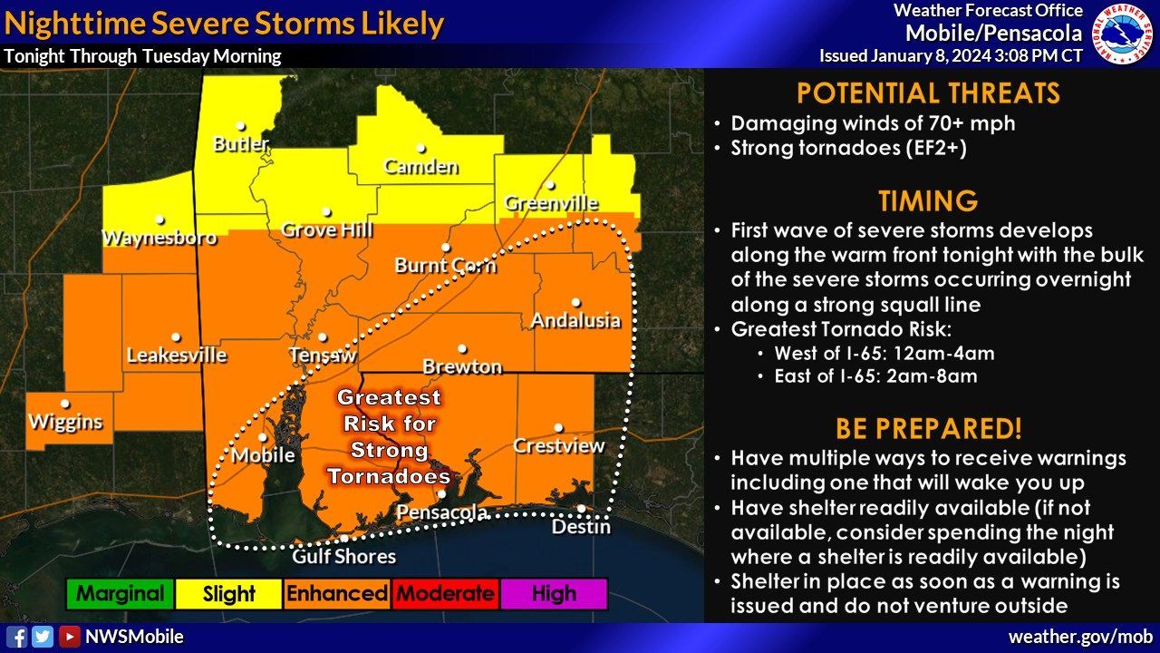
- There's a high concern for an impactful system tonight, with conditions worsening.
- Severe storms and tornadoes (EF2+), damaging winds (70+ mph) expected, with the highest tornado risk between 12-4am west of I-65 and 2-8am east of I-65.
- Strong winds are forecasted, with very windy conditions along the coast (gusts up to 60mph).
- Coastal impacts include life-threatening rip currents, high surf (10-15 feet), and moderate to minor coastal flooding.
City of Foley:
- A Red Cross shelter is open at St. Paul's Episcopal Church in Foley. People should bring their own food, medication, bedding, and toiletries.
Baldwin County Commission:
- Residents and visitors are advised to monitor local weather and be prepared.
- High wind warnings and coastal flood warnings are in effect.
- The American Red Cross has set up a safer place at St. Paul's Episcopal Church, Foley.
- Baldwin County EMA recommends signing up for local emergency alerts, having an emergency plan, avoiding misinformation, and being prepared with supplies.
Stay informed and stay safe.
From the National Weather Service Mobile:
🛑To quote our Area Forecast Discussion "No mincing words here, our concern for the overnight period tonight is serious. An incredibly impactful system has begun across our area and conditions will rapidly deteriorate throughout the night."
🌪️ SEVERE STORMS/TORNADOES - The potential for significant severe appears likely across most of the area including several significant tornadoes (EF2+) and damaging winds 70+ mph. The greatest tornado risk is generally from 12-4am for locations west of I-65 and 2-8am for locations east of I-65.
🌬️ STRONG WINDS - Windy conditions are expected area-wide tonight VERY WINDY conditions along the coast (gusts to 60mph). A *rare* STORM WARNING remains in effect for all Gulf waters, bays, sounds, and waterways for sustained winds of 30-40 knots and gusts to 55 knots.
🌊 COASTAL IMPACTS - LIFE-THREATENING RIP CURRENTS will persist through Wednesday night. The surf will continue to build to 10-15 feet through Tuesday night. MODERATE COASTAL FLOODING (3ft MHHW) is now expected tonight along the coast of Mobile and Baldwin Counties with MINOR COASTAL FLOODING for northwest Florida. Beach erosion expected.
Click here to view Graphics.
From the City of Foley:
Red Cross shelter opens in Foley
FOLEY – The American Red Cross has opened a shelter at St. Paul's Episcopal Church at 506 North Pine in Foley for anyone needing shelter during the severe weather threatening the area Monday.
The facility is not a county shelter and does not have amenities. Anyone who feels that they will need shelter can come to the facility, but those seeking shelter should bring their own food, medication, bedding and basic toiletries.
On Monday night, the National Weather Service predicted 30 to 35 mile an hour winds with gusts as high as 55 in the Foley area. The forecast also predicted 2 to 3 inches of rain in the area.
From the Baldwin County Commission:
Good afternoon,
Baldwin County Emergency Management Agency is encouraging the residents and visitors of Baldwin County to monitor local weather and be prepared should we have direct impacts to our area.
An updated message from the National Weather Service of Mobile:
“We have a few updates regarding the potential for high winds and coastal flooding and a minor adjustment to the threat for severe storms/tornadoes. Everything else mentioned in this morning's webinar/email remains the same.
TORNADOES - The greatest tornado risk for locations west of I-65 is from 12am-4am and 2am-8am for locations east of I-65. The greatest risk for strong tornadoes (EF2+) is generally east of I-65 (now outlined on the graphic).
WIND - The High Wind Warning was expanded to include all of Escambia, Santa Rosa and Okaloosa counties in Florida for the potential for wind gusts to 60 mph. A High Wind Warning remains in effect for central and southern portions of Mobile and Baldwin counties in Alabama.
COASTAL FLOOD - A Coastal Flood Warning is in effect from 6pm this evening until 6am Tuesday for coastal portions of Mobile and Baldwin Counties (3 feet of inundation above normally dry ground expected along the coast). A Coastal Flood Advisory remains in effect for coastal portions of Escambia, Santa Rosa, and Okaloosa Counties.
Please see the attached graphics for additional information.”
- American Red Cross will open St. Paul's Episcopal Church (506 N Pine St. Foley, Al 36565) as a "Safer Place" at 6:30pm tonight for those who may need a place to go during the potential for severe weather. Please make sure to bring your own sleeping bags, pillow, medications, supplies, food, etc. For more information, please call 251-256-8202.
We would like to remind you that now is a good time to do the following:
1. Sign up for local, emergency alerts through www.alertbaldwin.com/. This system allows Baldwin County EMA to send updates before, during, and after a disaster. You will also receive automated messaging from the National Weather Service of Mobile to conveniently stay informed.
2. Encourage your clients, businesses, family members, neighbors, and friends to sign up for AlertBaldwin.com.
3. Have any necessary supplies and important documents gathered and easily accessible.
4. Make sure you have an emergency plan created and discuss the plan with your family. www.ready.gov/plan
5. Steer clear of misinformation (especially on social media). Have multiple forms of receiving CORRECT information. (Baldwin County EMA, National Weather Service of Mobile, Local media outlets, etc.)
6. Monitor daily beach conditions and be aware of flag warnings. For a daily beach report, text ALBEACHES to 888777.
7. Visit our website for more information and tips on preparing for severe weather. www.baldwincountyal.gov/EMA
8. Don't forget to also use the dedicated text lines for Riviera Utilities (text OUT to 251-943-4999) and Baldwin EMC (text Outage to 85700) to report any power outages.
9. If you experience any storm damage tonight or tomorrow morning, please report it to the Baldwin County EMA at www.BaldwinCountyAL.gov/EMA
10. Call duty number for Baldwin EMA is 251-239-4322
BCEMA and local officials are monitoring conditions and will update as any new information becomes available through National Weather Service of Mobile.
If you are in a position that allows you the opportunity to share information with the public, please pass along. We appreciate your help in reaching as many residents and visitors in Baldwin County so that we can spread awareness and encourage preparedness.
Please reach out if you have any questions.
Thank you and stay safe,
Share this article w/ Friends...