Tropical Cyclone 9 Forecast to Become Hurricane Helene Before Making Landfall In Florida
Projected path of forecasted Hurricane Helene
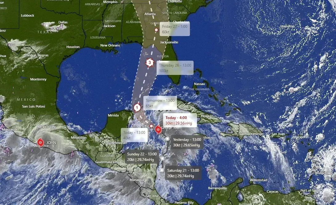
Orange Beach, Ala. – (OBA) – While the future Hurricane "Helene" is not forecasted to be a direct threat to the Alabama coast, locals should stay alert for wind, rain and surf reports. The storm is projected to strengthen and make landfall as a major hurricane in Florida's big bend area.
As is passes through the Gulf of Mexico, NOAA is forecasting the following weather for the Orange Beach area:
Wednesday
A chance of showers and thunderstorms, then showers and possibly a thunderstorm after 1pm. High near 84. North wind 5 to 10 mph becoming east in the afternoon. Chance of precipitation is 80%. New rainfall amounts between a quarter and half of an inch possible.
Wednesday Night
Showers and possibly a thunderstorm before 1am, then showers and thunderstorms likely between 1am and 4am, then showers likely and possibly a thunderstorm after 4am. Low around 73. East wind 10 to 15 mph, with gusts as high as 20 mph. Chance of precipitation is 80%.
Thursday
Showers likely and possibly a thunderstorm. Mostly cloudy, with a high near 81. Breezy, with a north wind around 20 mph, with gusts as high as 40 mph. Chance of precipitation is 70%.
Thursday Night
A 20 percent chance of showers and thunderstorms before 1am. Partly cloudy, with a low around 71. Breezy, with a west wind of 15 to 20 mph, with gusts as high as 35 mph.
Friday & Saturday
The weather on Friday and Saturday should be clear with lots of sunshine and highs in the low 80s.
SEE REAL-TIME RADAR AND WINDS HERE
As locals are aware, the path of a hurricane can quickly change. Remember to stay aware and check at weather.gov for any changes to the storm's path. You can quickly check our link HERE for real-time satellite views and wind reports.
Related Article: Historic Hurricanes and Tropical Storms that Impacted Baldwin County
Share this article w/ Friends...