Tropical Storm Helene Winds Strengthened to 70 MPH
T.S. Helene expected to become a hurricane later today
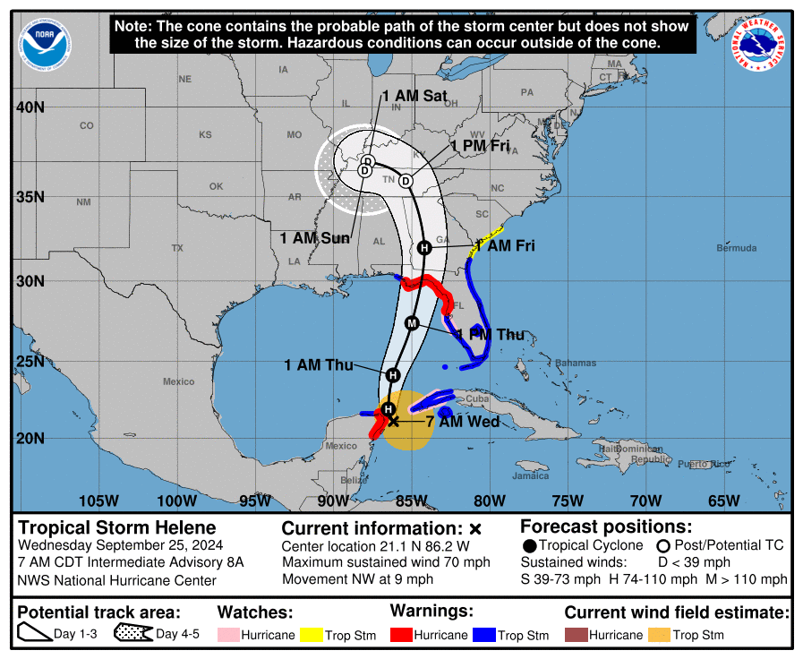
Orange Beach, Ala. – (OBA) – As of the 7:00am CDT Advisory, Helene winds have increased to 70 mph just off the Yucatán Peninsula, near Cancun. The storm is traveling to the northwest at 9 mph.
The forecast calls for Helene to become a hurricane later this morning and shift its track to the north/northeast. The forecast track has remained the same for the last few days and it is expected to make landfall in the Big Bend area of Florida tomorrow evening as a Cat. 3 hurricane.
As Hurricane Sally has taught us forecast tracks can change quickly. Gulf Coast residents from New Orleans to Tampa should keep an eye on Hurricane Helene for the next 24 hours, in case of a change of direction.
As Helene passes through the Gulf, NOAA is forecasting the following weather for the Orange Beach area:
Wednesday
A chance of showers and thunderstorms, then showers and possibly a thunderstorm after 1pm. High near 84. North wind 5 to 10 mph becoming east in the afternoon. Chance of precipitation is 80%. New rainfall amounts between a quarter and half of an inch possible.
Wednesday Night
Showers and possibly a thunderstorm before 1am, then showers and thunderstorms likely between 1am and 4am, then showers likely and possibly a thunderstorm after 4am. Low around 73. East wind 10 to 15 mph, with gusts as high as 20 mph. Chance of precipitation is 80%.
Thursday
Showers likely and possibly a thunderstorm. Mostly cloudy, with a high near 81. Breezy, with a north wind around 20 mph, with gusts as high as 40 mph. Chance of precipitation is 70%.
Thursday Night
A 20 percent chance of showers and thunderstorms before 1am. Partly cloudy, with a low around 71. Breezy, with a west wind of 15 to 20 mph, with gusts as high as 35 mph.
SEE REAL-TIME RADAR AND WINDS HERE
As locals are aware, the path of a hurricane can quickly change. Remember to stay aware and check at weather.gov for any changes to the storm's path. You can quickly check our link HERE for real-time satellite views and wind reports.
Share this article w/ Friends...